Close your eyes and picture "Arizona". Does that flash a slide show of brightly colored images? Visions of spicy SouthWest food platters, or the intense colors of flowering cactus, perhaps the primary hues of chile ristras hanging in an open-air market, and even some colorful people. Arizona colors are bold, except when they're dusty, or old or sun-bleached. I love it all. Well, not so much the old, dusty, rutted dirt roads. Those I will take in very small doses.
Along the 60-mile drive from Wickenburg to Prescott (historic US Route 89) the map showed County Road 109, a side road leading to the ghost town of Stanton. That sounded interesting so we set off to explore. Oh my, what a long, lumpy bumpy detour those few miles turned out to be. We traveled very slowly, 15 to 20 miles per hour, to avoid being bounced off the Explorer's headliner. Each mile of scenery looked the same as every other mile. I called "Stop!" for a picture of any interesting sight, just to get out of the car and walk around.
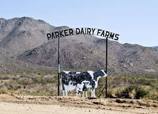
Interesting sight 1: a bullet-riddled sign for a dairy farm not far from the city. There was no green pasture here - do you suppose the cows care?
Interesting sight 2: a handful of range horses, curious to see if we had any treats I suppose. What do they graze on, in the midst of acres and acres of dry ground and cactus?
Interesting sight 3: some pieces of mining equipment scattered around the hills, but not a person in sight (not aboveground anyway).
I had expected Stanton to be a quiet, deserted site with a few old buildings. So why was there so much traffic kicking up dust on this stretch of gravel road? Weeks later I googled Stanton and discovered the old ghost town is now owned by the Lost Dutchman’s Mining Association and has been transformed into an RV campground. That explained the traffic, but not why RVers would find this location so attractive. These must be serious hobbyists who come to prospect for gold in the Rich Hill area. There were scores of white sticks in the ground everywhere that could have been claim stakes. LDMA owns 125 acres; ample room for a lot of prospecting.
Stanton appears much tamer now than it was during its Gold Rush past. (click here for a summary) Following an 1863 gold discovery at nearby Rich Hill, the stage stop called Antelope Junction grew rapidly into a boom town. Charles P. Stanton (a colorful, perhaps unsavory character) renamed the town after himself in 1871. Stanton was shot and killed in his store in 1886, but the town continued to prosper until gold mining ended and it finally became a ghost town.
Interesting Stanton factoid: (found here)
The Saturday Evening Post, which bought the town in the late 1950s, gave the 10-acre site away in a jingle contest. The New York winner of the contest had no idea what to do with a beat-up ghost town and sold it.Notice the dusty, curving gravel road heading up the the hill in the photo below. County Road 109 remained as bumpy as ever on drive out of Stanton. However the scenery became greener as we wandered up and over one hill, down and around another hill, and up another hill... Finally we reconnected with Hwy 89 at Yarnell and continued on the way to Prescott.
We departed Wickenburg, elevation 2056 feet, in the warm morning sunshine. By late afternoon the pine tree city of Prescott, elevation 5400 feet, offered cooler sunshine. Cool? oh yes, there was snow on the ground along the shady side of the road. It felt like we had toured two different Arizonas in one day.


No comments:
Post a Comment
Leave a friendly comment with your name please, and it will show up soon (after it is moderated).